New NASA Satellite Image Reveals Gold Mining Surge Around Ghana's Sacred Lake Bosomtwe
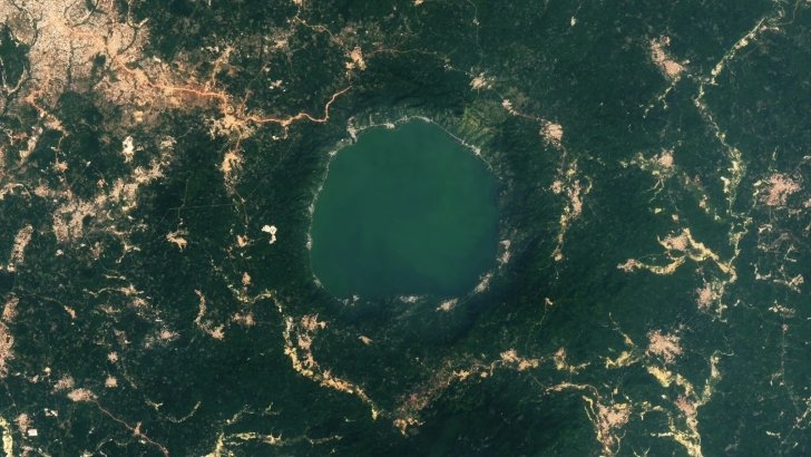
A striking satellite image captured by NASA’s Landsat 8 on December 21, 2024 has laid bare the dramatic expansion of gold mining around Lake Bosomtwe, Ghana’s only natural lake and a site of deep cultural and scientific significance. The photograph shows tendrils of exposed gold-bearing rock radiating outward from the crater rim — the visible legacy of an asteroid impact that occurred more than one million years ago and, increasingly, of human extraction that has accelerated sharply over the past decade.
Lake Bosomtwe, a bowl-shaped body of water southeast of Kumasi in the Ashanti Region, spans 49 square kilometres and reaches depths of up to 70 metres. It sits within one of the youngest and best-preserved complex impact craters on Earth, formed when a roughly one-kilometre-wide asteroid slammed into the African rainforest. The collision fractured the Earth’s crust, allowing mineral-rich magma to rise to the surface and deposit shallow veins of gold that have been mined for generations.
In recent years, however, advances in technology have driven a marked increase in artisanal mining activity around the lake. A comparative analysis of satellite imagery from 2015 and 2024 shows visible expansion of mining operations, particularly to the southwest of the lake, alongside rapid growth of farmland and settlements encroaching on the crater rim.
“The stark visual evidence of anthropogenic change juxtaposed with a million-year-old geological landmark is striking,” said Marian Selorm Sapah, a senior lecturer in the University of Ghana’s Department of Earth Science. “The clear encroachment of settlements, agriculture, and mining activities right up to the lake’s steep crater rim is a testament to both the image resolution and the scale of the change.”
A team of NASA-funded scientists has developed an application that uses Landsat images to track the expansion of gold mining in the region, distinguishing between artisanal and industrial-scale operations. Most of the new mining visible around the lake has been classified as artisanal — typically more superficial than industrial open-pit mining, but often leaving behind swathes of deforested land and mercury-contaminated waterways.
The lake itself appears greener in the 2024 image compared to earlier photographs, a change researchers attribute to higher concentrations of phytoplankton. Some studies suggest that land-use changes near the lake may be contributing to increased nutrient loads, fuelling the growth of certain phytoplankton species.
Beyond its ecological importance, Lake Bosomtwe holds deep cultural significance. In Ashanti tradition, the lake is considered a sacred site where souls bid farewell to Earth before entering the afterlife. An oral narrative passed down through generations tells of a hunter named Bompe and his dog Daakye, who pursued a wounded antelope into a small pond that rapidly swelled into the lake — a combination of the Ashanti words for god (Bosom) and antelope (Otwe) giving the lake its name.
Modern geology offers a more explosive origin story. Scientists believe the impact would have generated a blinding flash of light, an immense fireball and a shockwave that flattened forests for dozens of kilometres. If a similar event occurred today, it would likely obliterate Kumasi and trigger an “impact winter” with devastating consequences for agriculture across the region.
The rampart crater structure visible in the satellite imagery — where material blasted from the impact settled in a raised, lobed pattern — is rare on Earth but more common on Mars and other bodies in the solar system. As a result, studying Lake Bosomtwe could provide insight into how extraterrestrial craters formed, adding scientific urgency to calls for its preservation.
The debate over how Ghana manages its mineral wealth — and who benefits from extraction — has intensified in recent months. Around Lake Bosomtwe, that tension is written on the landscape itself: a million-year-old geological wonder increasingly scarred by the pursuit of gold.
Image Source: MYJOYONLINE